- Mormon Classics E-Texts Presented by Dale R. Broadhurst -


Book of Mormon Authorship
(2nd. edition, revised e-text version)

by: Vernal Holley,

(UT, self-published, 1989.)

Entire contents copyright ? 1989 by Vernal Holley.


Contents  &  notes  |   Part 1  pp.  5 - 24  |   Part 2  pp.  25 - 31  |   Part 3:  pp.  48-53  54 - 59  60-66  67-70


Note: The third edition of Mr. Holley's book will be made available
on-line at  SolomonSpalding.com


Return to page 47


[ 48 ]


SMITH, STOWELL, AND KNIGHT

Joseph Smith seems to have had an unusually close relationship with Josiah Stowell and Joseph Knight, through the years, from the time Smith first claimed knowledge of the ancient Nephite record, until the Book of Mormon was published.

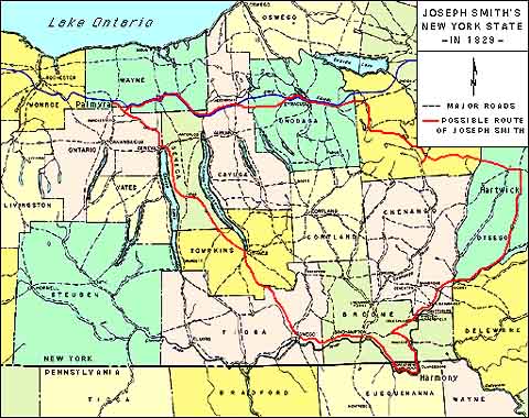
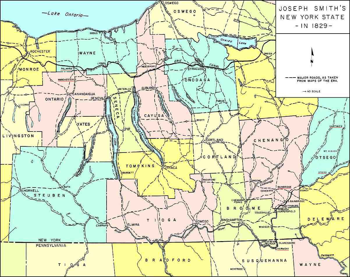
In October 1825, at the age of 20, Smith went to work for, and lived with, Josiah Stowell of Chenango County, New York. He was still living there in March 1826 when he was arrested and stood trial for "glass looking," a misdemeanor. Stowell testified in Smith's behalf at that trial [and] Smith was dismissed on "leg bail."40

Later, A. W. Benton wrote: "In this town (South Bainbridge, N.Y.), a wealthy farmer, named Josiah Stowell, together with others, spent large sums of money in digging for hidden money, which this Smith pretended he could see, and told them where to dig; but they never found their treasure."41

In January 1827 Smith married Emma Hale. Later that year, he went to work for Joseph Knight in neighboring Broome County.42 Knight was also involved with the "money digging,"43


-----------------------
 40  Letter of Judge Joel K. Noble, Turner Collection, Illinois State Historical Library.
 41  A. W. Benton, letter to the editor of the Evengelical Magazine and Gospel Advocate, April 9, 1831.
 42  B.H. Roberts, A Compregensive History of the Church, 1965, vol. 1, p. 85.
 43  Marvin Hill, Dialogue, A Journal of Mormon Thought, winter 1972, p. 78.


[49]


The Nephite Records

It was during these years that Smith first claimed knowledge of the ancient Nephite records which later became the Book of Mormon.

Stowell and Knight were both in the Smith home the night before Smith came into possession of the Nephite record. B. H. Roberts tells us:
In relation to the matter of the prophet Joseph obtaining the Nephite record on the morning of the 22nd of September. . . It appears that both Joseph Knight of Broome County, New York, and also a Mr. Josiah Stoal were present at the Smith homestead on the night of September 21st, 1827. 44
When Joseph Smith returned to the Joseph Smith Sr. home on the morning of September 22 with the record, Josiah Stowell was the first person to take the record from Smith's hands.45

Was it just a coincidence that Knight and Stowell were in the Smith home the very night Smith obtained the Nephite record? or did they have some purpose (relating to the event) for being there?


The Canadian Revelation

The following story is related by David Whitmer:
When the Book of Mormon was in the hands of the printer, more money was needed to finish the printing of it. We were waiting on Martin Harris who was doing his best to sell a part of his farm, in order to raise the necessary funds, After a time Hyrum Smith and others began to get impatient. . . they should not wait any longer on Martin Harris, and that the money should be raised in some other way. . . Brother Hyrum said it had been suggested to him that some of the brethren might go to Toronto, Canada, and sell the copy-right of the Book of Mormon for considerable money; and he persuaded Joseph to inquire of the Lord about it. Joseph concluded to do so. He had

-----------------------
 44  B.H. Roberts, New Witnesses for God, vol. 2, p. 58
 45  Ibid., p. 316.


[50]


not yet given up the stone. Joseph looked into the hat in which he placed the stone and received a revelation that some of the brethren should go to Toronto, Canada, and that they would sell the copy-right of the Book of Mormon. Hyram Page and Oliver Cowdery went to Toronto on this mission, but they failed entirely. . . 46
Hiram Page, who accompanied Cowdery on the mission to Canada, tells a slightly different story:
Joseph herd (sic) that there was a chance to sell a copyright in Canada for any useful book that was used in the states. Joseph thought this would be a good opertunity (sic) to get a handsome sum of money, which was to be (after the expenses were taken out) for the exclusive use of the Smith family, and was to be used at the disposal of Joseph. Accordingly, Oliver Cowdery, Joseph Knight, Hiram Page and Joseah Stoel [Josiah Stowell] were chosen to do the buoiness (sic). . . 47
David Whitmer's account of the Canadian mission tells that only Oliver Cowdery and Hiram Page were sent to Canada. Does David Whitmer omit the names of Joseph Knight and Josiah Stowell for some wise purpose? Did Knight and Stowell go to Canada to protect their interest in the monies that might come from the sale of the copyright?


Knight's History

Sometime between 1835 and 1845 Joseph Knight wrote a history of Joseph Smith's early years.48 In this account Knight tells of his personal involvement with Smith, and that after Smith received the ancient record, Smith and his wife returned to Pennsylvania where he began the translation. On several occasions, while they were living in Pennsylvania, Knight helped the Smith's with food and supplies and visited them so often that Knight's wife on one occasion asked him, "Why are you going again so soon?"

Knight tells us that Josiah Stowell later moved the Smiths to the Joseph Smith, Sr. home in Palmyra. In the spring of 1830, Knight visited Smith in Palmyra for several days at the same time Martin Harris was there. Knight "stayed a few days waiting for some books (Book of Mormon) to be bound."


-----------------------
 46  David Whitmer, An Address to All Believers in Christ, Richmond, Missouri, 1887.
 47  Letter of Hyrum Page to William McLellin, Feb. 2, 1848, copy in possession of the author.
 48  Joseph Knight, Manuscript of the Early History of Joseph Smith, LDS Church Archives.


[51]


In the fall of that same year, Smith visited Knight on some business at Knight's home in Pennsylvania. While Smith was at the Knight home, "a young fellow by the name of Doctor Benton in Chenango County. . . swore out a warrant against Joseph for, as they said, pretending to see underground." Smith was arrested that evening at the Knight home. Knight asked if he wanted counsel, and Smith said he, thought he should. That night, Knight hired James Davidson, a man he was acquainted with, and John Reed, another lawyer, to defend Smith. The next morning, Smith was brought before Justice of the Peace Chamberlain who dismissed him after an all-day trial. Smith was immediately arrested again and taken to Broome County for another trial on the same kind of charge. Again, he was dismissed. Joseph Knight paid the lawyer fees for both trials.


Judge Noble's Letter

Judge Joel K. Noble, who presided over Smith's second 1830 trial, reates an account similar to that of Joseph Knight, but with some: interesting additional information:
. . . Jo. Smith (Mormon) came here when about 17-18 y. of age in the capacity of glass looker or fortune teler (sic). At that time his physiognomy indicated almost anything rather than native good common sound sense.

Sir I do think I am not mistaken in the above - - - You may then enquire [to] ask me behold what Jo. has don[e.] I s[a]y Jo. is the cat's paw the Lion is behind the curtin (sic) You then en[quire] who is the Lion I say Mr. Rigdon was not the Lion until after the Book of Mormon was printed. He may be the Lion now You yet en[quire] who was the Lion (first) was I [to] say 2 individuals names of 2 I keep for present-- I am well aware that it went the round in many P[ennsylvania] papers that the B. of M. was w[ritten] first for amusement and received a dressing by some individual said by some to [be] Mr. Rigdon Sir this is incorect I can prove (absolute) Mr. Rigdon did not 2 individuals did (not bostingly) (sic). . . his [Smith's] haunt was Palmyra and Harmony (Penn) Bainbridge (in the dark) making a triangle-- 49
Judge Noble seems to be quite sure that Joseph Smith was not the originator of the Book of Mormon, and clearly places its origin on


-----------------------
 49  Letter of Judge Joel K. Noble, March 8, 1842, Turner Collection, Illinois State Historical Library.


[52]


Conclusion

"2 other individuals." Stowell and Knight must be considered as possibly being the two individuals referred to by Judge Noble.


Joseph Smith at Hartwick?

Judge Noble's declaration that Joseph Smith and his followers traveled in a "triangle," -- the [sides of the triangle being the roads from] Palmyra (New York), [to] Harmony (Pennsylvania), [then to] Bainbridge (New York), [and] then back to Palmyra -- may not have been a complete description. The geographical locations, and the available routes of travel, between these three towns do not constitute a triangle. According to F. G. Mather, Smith and his followers (Knight and Stowell?) operated with Smith's "peek-stone" [17 miles NE of Bainbridge] in Otego, Otsego County, "in this part of the valley where he (Smith) was a comparative stranger."50 From Otego Smith and his followers may have continued up the Susquehanna River [and adjoining Otego Creek] a day's journey and stayed overnight at Hartwick, Otsego County, with Josiah Stowell's relative, David Stowell. If Smith did visit Hartwick, his route of travel (from Palmyra to Harmony, Bainbridge, Hartwick, then back to Palmyra) would have constituted a triangle. The writings of Solomon Spaulding [then] lay in a trunk in the home of John Davison [sometimes spelled "Davidson," like Smith's lawyer in neighboring Chenango County] of Hartwick, whom the widow Spaulding [had] married in 1820.

In 1833 Philastus Hurlbut attempted to obtain the [supposedly original] Book of Mormon manuscript from the Davison home but [reported that] he found only [Spaulding's] Roman story. If Spaulding's widow had a trunk full of Spaulding's writings at Hartwick in 1820, who took them all away but one? If Joseph Smith really succeeded in getting the Book of Mormon manuscript from Mrs. Davison's trunk (or if someone did it for him), this would account for its disappearance from the trunk before 1833.


Turner's Account

In 1843 J. B. Turner wrote of these events concerning Joseph Smith:
The point to be noticed here is, that from 1823 to 1827, the precise four years in which Smith and his friends, in all the Mormon journals, either by accident or design, omit all accounts of him, he is passing to and fro, from his native place to Chenango county, N.Y., and then to Harmony, Penn., which is near by; he is seemingly out of employ, and resources, and friends; and, by his own confession, employed a part of his time in digging for a cave of silver, by Stowell.

-----------------------
 50  F.G. Mather, "The Early Days of Mormonism," Lippencott's Magazine, Aug., 1880.


[53]

He was, therefore, in the society of men not only ready to believe, but on the look-out for wonders and sudden speculations.

Why have neither Smith nor his friends given any history of these four years, between the two miraculous visits of the angel, viz. from Sept. 22, 1823, to Sep. 22, 1827, when he first obtained the plates? Why does Smith pass over this most interesting portion of his life in silence, or speak of it only in vague generalities? The only possible answer is, he dares not give a minute and detailed history of that period, giving places and dates; for if he should, he fears it would lead to his detection. No other reason can be given, though he may patch up something after these suggestions.51


Note:
The red line shows a possible triangular route traveled by Joseph Smith, jr., as described by Judge Joel K. Noble. [Otego is on the eastern side of the triangle, from there the route goes to Hartwick and then NW to Palmyra.]

Click here for a larger, more detailed map of the area c. 1829

Click here for a larger, more detailed map of the area printed in 1834


[54]

BOOK OF MORMON GEOGRAPHY

The Book of Mormon text does not identify the actual location of its [story's] setting, and Mormon Church authorities have never issued an official statement to establish the location. However, the traditional belief of faithful Church members is that a major portion of the history took place in either South or Central America, an assumption that seems to have evolved from early beliefs.

Early Mormon leaders, Franklin D. Richards, James A. Little, and Frederick G. Williams, all stated that the landing place of the Book of Mormon Lehite voyagers was "on the continent of South America, in Chili, 30 degrees south latitude."52 One of the first ordained apostles in the Mormon Church, Orson Pratt, was also a proponent of the Chilean location. On three occasions between 1867 and 1872, Pratt speaking from the pulpit, told his listeners the landing place was on the coast of Chile. According to Pratt, "30 degrees south latitude was not far from where the city of Valparaiso now stands."53

Many problems surface, however, when Book of Mormon geographical descriptions are compared with the actual geography of either South or Central America. Because of these problems and because literary similarities exist between Spaulding's Manuscript Story and the Book of Mormon, it seems reasonable to question whether or not the geographical descriptions in the Book of Mormonfit those of the Great Lakes area [as described] in the Spaulding story.

Since there are few apparent contraditions among the geographical descriptions in the Book of Mormon, [(see page 59, note 59 for the solution to one possible contradiction) the reader can assume that its geographical information is internally consistent and that] the author had a definite area in mind when he wrote the story.

If Solomon Spaulding did in fact make a substantial contribution to the Book of Mormon [text] then the geographical account in that book, [as well as the one found in Manuscript Story] may also have been his work. The geographies [of these] two texts is compared in this section.

Spaulding's account tells of settlements existing throughout "the whole country on both sides of the Ohio River. . . also along the Great Lakes of Erie and Michigan. . . and in some part of the country which borders on Lake Ontario" (Manuscript Story pp. 20, 54). The entire area was [encompassed] within a five or six hundred mile radius [of Spaulding's Conneaut home] and included the present states of New York, Pennsylvania, and Ohio, [along with portions of outlying regions such as Michigan, Kentucky, and Ontario].

There are many place names in the Book of Mormon; only a few have good location descriptions. We know that the city of Zarahemla was on the west side of the River Sidon and that the land of Minon was on the east. We know that there was a narrow neck of land that separated the "land northward" from the "land southward" and that the lands of Zarahemla and Bountiful were in the land to the south, adjacent to the narrow neck of land. We also know that the Hill Cumorah was in the land to the north. In recent years, Mormon scholars have tried to confirm their belief that these


-----------------------
 52  Paul R. Cheesman, The World of the Book of Mormon, 1978, pp. 22-23.
 53  Journal of Discourses, vol, 12, p. 342; vol. 13, p. 129; vol. 14, p. 325.


[55]


locations existed in either South or Central America, but the geographical descriptions within the Book of Mormon do not support this theory.

Stories within the text give us some indication of the distance between the different locations, An example is in the story of Alma: he fled into the wilderness with his people to escape the king's men. He fled from the land of Shilom, near the landing place of the Lehites, to the city of Zarahemla, near the narrow neck of land. This journey was made in twenty-one days (Mosiah 23:3, 24:20, 24:25).

According to George Reynolds, in his Concordance of Book of Mormon, the land of Zarahemla was in northern Colombia. If the landing place of the Lehites was on the coast of Chile, as stated by early Mormon leaders, and the land of Zarahemla was in northern Colombia, Alma would have traveled approximately twenty-seven hundred miles in twenty-one days, averaging one hundred twenty-eight miles per day. The journey would have required Alma and his party to cross the Andes Mountains and to ford many rivers while driving their flocks and conveying provisions necessary to support four hundred fifty people (Mosiah 23:1, 18:35). Because such an accomplishment seemed impossible, Mormon scholars have searched for more logical locations for these and other Book of Mormon sites, including the landing place of the Lehi party and the narrow neck of land that led to the north countries.

After explorer John L. Stephens published in 1841 his Incidents of Travel in Central America, Mormon Church leaders changed the location of Book of Mormon geography from the traditional South American area to Central America54 This changed the location of the city of Zarahemla to a new site and identified the Isthmus of Tehuantepec as the narrow neck of land of the Book of Mormon. However, this new theory also proved to be controversial. Mormon author Hugh Nibley said: "To call the Isthmus of Tehuantepec, one hundred and thirty miles wide, a narrow passage is of course out of the question."55 The Book of Mormon states that the narrow passage was "only the distance of a day and a half's journey for a Nephite" (Alma 22:32). It is obvious that neither location chosen by Mormon scholars for Book of Mormon geography is compatible with the evidence within the text.

Joseph Smith, who claimed to have translated the ancient record through divine guidance, seemed also to [have been] ignorant of Book of Mormon geographic locations.
In 1836, the Prophet Joseph Smith, Brigham Young, and others, found it best, on account of apostasy and bitterness, to leave Kirtland and go to Far West, Mo., where the Saints were endeavoring to establish themselves. On September 25, they passed through Huntsville, Randolph Co., and the Prophet is said to have told the brethren that that place, where a stake of Zion had been established, was the ancient site of the citv of Manti.56

-----------------------
 54  Times and Seasons, vol. 3, no. 23, (1842), p. 927.
 55  Hugh Nibley, An Approach to the Book of Mormon, 2nd ed., 1976, p. 361.
 56  Reynolds and Sjodahl, Commentary on the Book of Mormon, vol 2 (1956), p. 324.


[56]


This statement, attributed to Joseph Smith, conflicts with the Book of Mormon description of the location of Manti. Commenting on this problem in his In Search of Cumorah, David Palmer said: "There is only one city of Manti referred to in the Book of Mormon. It was by the 'head of the river Sidon. . . there is no possible way for a site up in the United States to have been the city of Manti."

If Joseph Smith had been inspired to make this statement, or if he had been the original author of the Book of Mormon, why would he have made such an error concerning the location of the Book of Mormon city of Manti? And why did he not correct the erroneous theories taught by other Church leaders about Book of Mormon geography locations?


Hill Cumorah

Joseph Smith claimed he obtained metal plates, cdntaining the ancient Book of Mormon record, from a hill near his home in New York State. However, the Book of Mormon description of the Hill Cumorah location is not compatible with it being in New York State.

One of the' many Book of Mormon stories that do not support this theory is the account given by Zeniff of a small party of men who left the land of Nephi in search of the land of Zarahemla. During their search, they became lost and happened onto the remains of an extinct civilization. Believing they had found the land of Zarahemla, they returned to the land of Nephi (Mosiah 21:25-26). The ruins they supposed to be the land of Zarahemla were actually the remains of the Jaredite people who had fought and died at the Hill Ramah, the same hill that was called Cumorah by the Nephites (Ether 15:11).

If the land of Nephi was in the traditional South or Central American location and the Hill Cumorah (Ramah) was in what is now New York State, the Nephites would have traveled a minimum of forty-six hundred miles in their journey. It is unlikely that these Nephites would have wandered from either South or Central America to the New York area while looking for the land of Zarahemla, which, according to Reynolds, was in northern Colombia. Mormonarchaeologist Joseph Vincent has reached the same conclusion:
If a sincere student of the Book of Mormon will conscientiously read and study the book itself and will plot out all the locations mentioned. . . he will find that all Book of Mormon lands lie within a five or six hundred mile radius, and that this area could not possibly extend from Chile to New York.57
This contradiction has caused many Mormon scholars to look elsewhere for the Book of Mormon Hill Cumorah location. David Palmer speculated that the hill was in southern Mexico. Fletcher


-----------------------
 57  Founteenth Annual Symposium on the Archaeology of the Scriptures, BYU, 1963, p. 68.


[57]


Hammond wrote, ". . .the only proper conclusion to be reached is: the Book of Mormon Hill Cumorah was somewhere in what is now Central America or southern Mexico."58 These theories present an obvious problem. If the Hill Cumorah of the Book of Mormon is in either southern Mexico or Central America, then how did the metal plates get from such a distant location to New York State? Speculation on this problem caused some Mormon scholars to conclude that Moroni, the last survivor of the Nephite nation, transferred a wagonload of metal plates from the Hill Cumorah of southern Mexico to the Hill Cumorah of New York State, where they could be found and translated by Joseph Smith (Palmer p. 20).

These contradictions, recognized by Mormon scholars, suggest that the writer of the Book of Mormon did not have the traditional location in mind when he wrote the Cumorah story. Either the Nephites did not live in South or Central America or the Hill Cumorah was not in New York State.


Sea East and Sea West

Most of the Book of Mornlon story setting was in or near the land of Zarahemla, which was adjacent to both the Sea East and the Sea West. Of the fourteen references to these seas in the Book of Mormon, none suggests that the Sea Aast was the Atlantic Ocean or that the Sea West was the Pacific. Yet this assumption is a common belief among members of the Mormon Church.

The Lehites reached their "land of promise" after crossing the "waters of the great deep." For the next three hundred and twenty years they lived near their landing place (Omni 1:15). During that time, the Seas East and West were not mentioned in the record. It was only after Mosiah and his people migrated to the land of Zarahemla that these seas were introduced into the story. This suggests that these were inland seas, near the land of Zarahemla, and not the Atlantic and Pacific Oceans.

If Spaulding [wrote the Book of Mormon to replace his unfinished Manuscript Story, but retained his original] Great Lakes area [setting, then] Lake Ontario would have been his Sea East and Lake Erie his Sea West (see footnote below,* and my Great Lakes area maps included in Figures 1 and 2 on pp. 60-61).


Hill Onidah

The Book of Mormon Hill Onidah was in the land of Antionum, east of Zarahemla (Alma 31:3, 32:4). About one hundred miles east of where I have placed the land of Zarahemla in New York State is a place called Oneida Castle. It is located on a hill in Oneida County and was the chief settlement of the Oneida Indians of New York. It seems more than coincidental that when the Great Lakes area is used as the setting for the Book of Mormon geography that this place has the same name, is also situated on a hill, and is in the same location as the Book of Mormon Hill Onidah.


-----------------------
 *  [Note: In 1844 local historian Harvey Nettleton explained that in early post-colonial times Lake Erie "was regarded as a distant solitary lake, situated far toward the setting sun, and its name intimately associated with that of the West Sea." ("History of Astabula County," as reprinted in the Geneva Times, no date, copy in the Dale R. Broadhurst Papers, Special Collections, Marriott Library at the University of Utah).]

 58  Fletcher Hammond, Geography of the Book of Mormon, 1959, p. 119.


[58]


River Sidon

In the Book of Mormon there are thirty-seven references to the River Sidon. It ran south to north and emptied into the sea. The line of fortification that divided the land of Zarahemla from the land of Nephi was close to the river's headwaters (Alma 50:11). If my Great Lakes theory is correct, the Genesee River in New York is the River Sidon of the Book of Mormon, It runs from south to north, empties into Lake Ontario, and fits all the descriptions given in the Book of Mormon for the River Sidon. [An alternative identification for the Sidon would be the Niagara River, which has its "head" in the "Sea West," (cf. Alma 22:28-29; 50:11). Such an identification would, however, reduce the area of the great Land of Zarahemla to an impossibly small patch of land in the neighborhood of the Niagara River's Grand Island and place the parallel "narrow strip of wilderness" atop the Welland Canal tract.]


Narrow Neck of Land

The most important geographic feature in the Book of Mormon is the "narrow neck of land." It is described as [being] "only a day and a half's journey" from sea to sea. It divided the land to the north from the land to the south (Alma 22:32).

If the Book of Mormon setting is placed in the Great Lakes area, Canada becomes the land to the north and the United States the land to the south. The thirty mile wide narrow neck of land between Lake Ontario and Lake Erie would take about a day and a half to cross on foot. North of the narrow neck of land in the Book of Mormon were "many waters, rivers, and fountains" (Mormon 6:4). North of my suggested narrow neck of land, in southern Ontario, the area is covered with many lakes, rivers, and springs.


Lines of Fortification

Several lines of fortification were described in the Book of Mormon. The first is spoken of in Alms 22:32. It was called the "line Bountiful" and its length was "a day and a half's journey" across the narrow neck of land from the east to the west sea. Apparently the Nephites gathered their armies to this line because it was a natural line of fortification. A seemingly inconsistent description of the line Bountiful is given by Helaman fifty years later in the story. He describes it as being "a day's journey for a Nephite on the line which they had fortified" (Helaman 4:7). The writer of the Book of Mormon apparently had Helaman retreat to the narrowest part of the neck of land to make another line of fortification. The proposed "narrow neck of land" between Lake Erie and Lake Ontario narrows in width from about thirty miles (a day and a halfs journey) to about twenty miles (a day's journey). It was used as a natural fortification line between the United States and Canada in two wars: the French and Indian War and the War of 1812

After driving the Lamanites southward, the Nephites built a different line of fortification to separate the two nations. That line ran from the west sea past the headwaters of the River Sidon (Alma 50:11) and, at that time, formed the southernmost boundary of the Nephite country. If Book of Mormon geography were placed in the context of Spaulding's Manuscript Story, this line of fortification would extend from Lake Erie (the west sea), east past the headwaters of the Genesee River. In his Geography of New York State,


[59]


J. H. Thompson says that sixty-seven ancient fortified earthworks have been found in an area extending from Lake Erie past the headwaters of the Genesee River and on into the Oneida Indian country.


Narrow Strip of Wilderness

The Book of Mormon describes a "narrow strip of wilderness" or natural land feature that divided the land of Nephi from the land of Zarahemla.59 It "ran from the Sea East even to the Sea West" (Alma 22:27).

In his Modern Geography (1822), Sidney E. Morse gives this description of an unusual ridge of land in the area of my proposed land of Zarahemla.
From Genesse River, near its mouth, to Lewiston on the Niagara River, there is a remarkable ridge running in a direction from east to west almost the whole distance, which is 78 miles. Its general height above the neighboring land is 30 feet: its width varies considerably, and in some places is not more than 40 yards  . . . and its distance from that water (Lake Ontario) is between 6 and 10 miles. . . about 20 miles south of this ridge and parallel with it, there is another, which runs from Genesee River to Black Rock on Niagara River.
The Book of Mormon writer may have thought of this area [the continuation of the Niagara Escarpment] as a narrow strip of wilderness running from the east sea to the west sea. [An alternative identification would be the Welland Canal lands, in Spaulding's day a narrow, N-S oriented strip of swampy low-lands which intersected the Niagara Escarpment just south of present-day St. Catherines, Ontario).


Land of Minon

In the Book of Mormon story, the writer says the Nephites followed the Amlicites from the hill Amnihu, which was east of the River Sidon, to the land of Minon (Alma 2:15, 24). In Ontario County, New York, east of the Genesee River, are the remains of an ancient fortified hill that today is called Boughton Hill.60 This ancient hill is in the same location as the hill Amnihu of the Book of Mormon, if my theory is correct.

Speaking before the New York Historical Society in December 1811, New York Governor DeWitt Clinton told of a tribe of Indians called "Minonion." The geographic descriptions of the land of Minon in the Book of Mormon (Alma 2:15-24) are [generally] compatible with this New York location [for the Minonion Indians].


Waters of Ripliancum

One of the north country battle areas in the Book of Mormon was near a place called the Waters of Ripliancum. These waters were described as being "large to exceed all" (Ether 15:8). The text does not explain what is meant by the phrase "large to exceed all." If the Great Lakes area was the intended story location of the Book of Mormon, the


-----------------------
 59  According to George Reynolds, in his Complete Concordance of the Book of Mormon, (1976), there are two places called Nephi and two called Zarahemla. If this is so, it would account for seemingly contradictory descriptions of these places.
 60  H.C. Shetrone, The Mound Builders, p. 276.


[60 - 61]


BOOK OF MORMON GEOGRAPHY
(cont'd.)


Maps of the Great Lakes Region

[Figure 1. below shows the actual landscape of the Great Lakes Region where Rev. Solomon Spaulding lived after leaving his home state of Conneticut in about 1795. Place names shown in brown represent the locations of imaginary cities and lands appearing in his Roman story manuscript. All the other features and sites are actual places existing before his death in 1816.


Holley1b.jpg 222x300 image

Figure 1. Actual Place Names and Locations [in the] Spaulding Story


Larger image of Figure 1.


[Figure 2. shows several of the Book of Mormon place names fit to the landscape of the Great Lakes Region. Several of the sites have the same names, or similar names, of sites at the same locations as in Figure 1. The inset in the upper left indicates the "Narrow Strip of Wilderness" ridge that runs between the Sea West and the Sea East.

Holley2b.jpg 222x300 image

Figure 2. Proposed Book of Mormon Lands Locations


larger image of Figure 2.


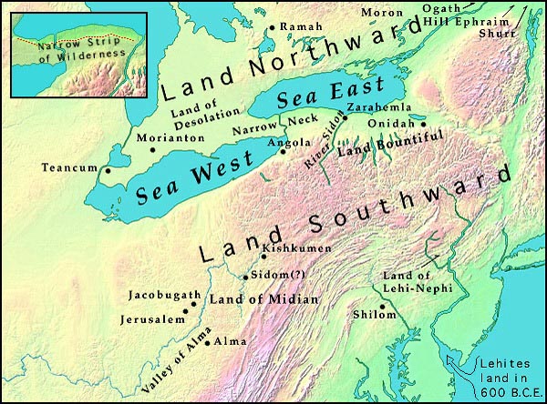
[62]


Waters of Ripliancum (cont'd.)

Waters of Ripliancum may have been Lake Superior, the largest of the five Great Lakes. On or near the north shore of Lake Superior are Ripple Bay, Ripple Creek, Ripple Reef, and Ripple Lake -- names surprisingly similar to the "Waters of Ripliancum." [One possible alternative identification could be the great natural wonder of Niagara Falls, whose outpourings "exceed all" other "waters" in North American waterfalls.]


Hill Ramah

In the Book of Mormon story, the armies of Coriantumr ["beat" the armies of Shiz and caused them to retreat "southward"] from Ripliancum. [The armies of Coriantumr apparently remained in the north country] and pitched their tents by the Hill Ramah (Ether 15:10-11). Today, south by southeast from Lake Superior (Waters of Ripliancum?), near Lake Simcoe in Ontario, Canada, is the Rama Indian Reservation,61 located within the boundaries of Rama Township62

The Book of Mormon Ramah was [relatively near] the Waters of Ripliancum in the "land northward," and, similarly, the modern day Rama Indian Reservation is located [relatively near] several place names with a "Ripple" designation, in Canada (the north country).


Book of Mormon Cities

The following modern place names are actually located in the area of Spaulding's Manuscript Story setting. All but a few can be found in gazetteers published prior to the Book of Mormon. Also shown is all companion list of Book of Mormon place names that are either identical or similar to the modern names listed. Some of these modern place names are located north of the Great Lakes in Canada. In each case, the parallel name in the Book of Mormon is in the area called the "land northward." An asterisk (*) identifies these places.


Modern MapsBook of Mormon
Agathe, Saint *Ogath
AlmaAlma
AngolaAngola
AntrimAntum
AntiochAnti-Anti
BoazBoaz
Conner *Comner
Ephrem, Saint *Ephraim, Hill
HellamHelam
JacobsburgJacobugath
JordanJordan
JerusalemJerusalem
KishkiminetasKishkumen
LehighLehi
MantuaManti
MonroeMoroni
MinoaMinon
Moraviantown *Morianton
Morin *Moron


-----------------------
 61  According to G.H. Armstrong, in his The Origin and Meanings of Place Names in Canada, Toronto, 1972,
        "Rama is the Greek form of Ramah of the Bible, which is said to mean 'high place'".

 62  J.G. Farewell, History of the County of Ontario, 1907.


[63]


Modern MapsBook of Mormon
Noah LakeNoah, Land of
OneidaOnidah
Oneida CastleOnidah, Hill
OmerOmner
Rama *Ramah
Ripple Lake *Ripliancum, Waters of
SodomSidom
ShilohShilom
lands of the MinonionLand of Minon
Tenecum (Tecumsah) *Teancum


City of Angola

One of the war stories related in the Book of Mormon was fought "in the borders of Zarahemla by the Waters of Sidon" (Mormon 1:10). Later the war resumed, and [Mormon's armies] retreated towards the "north countries." [At this time they occupied] a city called Angola (Mormon 2:4).

The present day city of Angola, New York, is located west of the Genesee (Sidon?) River and south ["in the borders"] of the proposed land of Zarahemla. This is another example of the many actual locations in the Great Lakes area that can be located on modern maps by following geographical information in the Book of Mormon.


City of Teancum

Teancum, a Book of Mormon city located in a land called Desolation, within the north country, was "in the borders by the seashore" (Mormon 4:3). It was named after Teancum, who fought and died in the land Desolation while helping the Nephite military commander, Moroni, contain the Lamanites who were trying to gain access to the "land northward" (Alma, Chapters 50-62).

The modern city of Tecumseh [Tenecum] is located in Canada (the land to the north), by "the borders" of Canada and the United States, and by "the seashore." It was named after the great Shawnee Indian chief, who fought and died as a military commander under the British in the War of 1812, while helping their forces contain the Americans, who were trying to gain access to British territory in Canada.


"King Gideon" [& the Land of Lehi-Nephi]

In 1750, the Delaware "king," Chief Tadeuskund, was baptized into Christianity and christened "Gideon." He was a counselor to his nation and negotiated peace with the other Indian nations. Gideon was eventually burned to death in Wyoming County, Penneylvania, after being supplied with liquor and made drunk63

The Book of Mormon tells a similar story of a "Gideon" who was a Christian convert of Alma. He was also a great peacemaker (Mosiah 20:17-21). Within this story, King Limhi desired baptism to Christianity, King Noah was burned to death, and the Lamanites were made drunk with a tribute of wine supplied by Gideon.


-----------------------
 63  Rev. John Heckewelder,History, Manners, and Customs of the Indian Nations, 1876, pp. 302-305.


[64]


The historical location of the Delaware King Gideon story was in the area of Lehigh County, Pennsylvania, near the [Roman's] landing place in the Spaulding story. The Book of Mormon Gideon story took place in the land of Lehi-Nephi, the landing place of the Lehites. [The Land of Lehi-Nephi may thus correspond to the land of modern Lehigh County.] The similarities between the elements of the two stories suggest that the writer of the Book of Mormon used [post-columbian] Indian history [and geography] as the basis for some of his stories, using the same ideas, but applying them to different parts of [his own] story. This suggestion [may be quite] significant, considering the fact that Spaulding wrote his Manuscript Story as a fictional history of the Delaware Indians [and their neighbors].


Kishkumen

The location of the Book of Mormon city of Kishkumen is not given in the text. However. there are names similar to Kishkumen, on modern maps, in the location of Spaulding's Manuscript Story setting.

In Spaulding's story, his travelers left their landing place on the Delaware River and traveled west across the "Great Mountain." They "came to the confluence of two great rivers which in conjunction produced a river which was called Owaho" (Ohio) (Manuscript Story, p. 18). This place was on the site of the present day city of Pittsburgh. Near this area, are the remains of an ancient Delaware Indian village named Kiskiminetas. A monument marks the site of the ancient village. There was also a group of Delaware towns called Kuskuski in Lawrence County, near the present-day site of New Castle.64 Another variation of this Delaware name, found on early maps, is Kishkiminetas.

The Book of Mormon Kishkumen appears to be yet another variation of this Delaware Indian name. Here, again, the evidence suggests that the writer of the Book of Mormon used [Anglicized] Indian place names and [elements of Indian] stories as ideas for his story about the ancestors of the American Indians.


TRAVELS OF SOLOMON SPAULDING

It is interesting to consider the influence that Spaulding's travels seemed to have had upon his writings. During his lifetime, he lived in several different locations.

In 1782, at age twenty-one, Spaulding left his birthplace in Connecticut to attend Dartmouth College in Hanover, New Hampshire. While there he became acquainted with Reverend Ethan Smith, who may have influenced Spaulding's interest in the origin of the American Indians. Based on information provided by Ethan Smith's grandson, an article65 was printed in the Cleveland Plain Dealer [of April 24, 1887], in which Ethan Smith was said to have written a manuscript based on the theory that the American


-----------------------
 64  C, Hale Sipe, The Indian Wars of Pennsylvania, 1929, p. 750.
 65  New York Public Library Mormonism Files: ZZMD, p. 20; see also Appendix C in David Persuitte, Joseph Smith and the Origins of The Book of Mormon, 1985.


[65]


Indians were descendants of the Lost Tribes of Israel. The 1887 article [published three decades before the "Ethan Smith as a Mormon Source" theories were first developed] also stated that he had shared his ideas with Solomon Spaulding while they were attending Dartmouth. [While finishing up his Masters degree, Spaulding's last days in the Dartmouth region appear to have overlapped Smith's first days at the college.] In 1823, Ethan Smith published a book dealing with [this] same subject [of Indian origins] entitled, View of the Hebrews. [The enlightened views on accepting, educating, and possibly even inter-marrying with the American Indians that appear in the writings of Smith and Spaulding were very much in vogue during their stay at Dartmouth, a college established for these very purposes. Spalding's notions regarding communal life may have been shaped during his years at Dartmouth -- following visits to the nearby Enfield Shaker Commune.]

After completing his training at Dartmouth, Spaulding [very likely remained briefly] in Hanover, New Hampshire, before moving to Windham County, Connecticut, where he finished his preparation for the ministry in 1787 and served as a licensed preacher [and evangelist] for eight or ten years. [According to his step-daughter, Matilda] one of his first writing efforts was a story entitled, "The Frogs of Windham," based on the actual happening in the area.

Cherry Valley, [Otsego Co.,] New York, was Spaulding's next home. For a short period, while living there, he served as principal of the Cherry Valley Academy. According to John Sawyer's History of Cherry Valley (1898), "It was during this time that the Rev. Solomon Spaulding. . . wrote the biblical romance, which afterwards fell into the hands of Joseph Smith, and was adopted by him as the basis of the Mormon bible." Spaulding may have only begun his biblical story at this early date, since it was said that he worked on it from time to time until at least 1812. [It is possible that local accounts of the 1778 Cherry Valley Massacre, coupled with his own experience of active duty with the Continental Army, influenced Spaulding to insert so much "blood and carnage" among the descendants of "bretheren" into his story-telling.]

From Cherry Valley, he moved then on to Conneaut, Ohio, where he [supervised a land-sales] business for his brother, Josiah. The known route of travel from [Otsego County, New York] to Conneaut, at that time, followed the old Indian trails that skirted around the mountains and rivers that lie between the two cities. It took the traveler around the north end of the Finger Lakes, across the Genesee River to the Niagara area, then along the shoreline of Lake Erie to Ohio. [In making this trek (perhaps partly by boat), Spaulding would have had ample opportunity to visit the Niagara region of southern Ontario, as well much of the American shoreline of Lake Ontario and Lake Erie.]

After failing in business at Conneaut and experiencing deteriorating health, Spaulding devoted most of his time to finishing the novel which he called "Manuscript Found." In 1812, [in the midst of the threat of a British-Canadian invasion] he moved from Conneaut to Pittsburgh, Pennsylvania. There he attempted to get his writings published. Failing in this endeavor, he moved to Amity, Pennsylvania, where he died in 1816.

When Spaulding's travels are tracked on modern maps, they encompass nearly all of my proposed Book of Mormon geographical locations. He had opportunity to obtain first-hand knowledge of ancient fortified earthworks, Indian place names, [biblically-derived] place names, and [unique] geographical locations that influenced his writings.


CONCLUSION

In this study, I have identified many similarities between Spaulding's Manuscript Story and the Book of Mormon. These are not [only the] vague similarities also found in [many other old] adventure stories; they are [generally unique] to the two works in question. How many books exist that have the same story outline as the Book of Mormon? How many stories tell of a record being written by the ancestors of the American Indians and buried by [the ancient people], to come forth at some future time when


[66]


other people inherit their lands? How many tell of [similar] worship ceremonies, cultural technology, Christian theology, seer stones, and give the same descriptions in their fortifications and war stories? How many novels tell of a [light-skinned demi-god] whose teachings brought about a long period of peace followed by a war between kindred tribes in which the losing people are exterminated? Many similarities in the literary style of the two works have also been identified, including [numerous] identical word combinations. The geographical settings of the two stories appear to be in the same area.

Most skeptical readers of Spaulding's Manuscript Story encounter difficulty in recognizing similarities between it and the Book of Mormon because they expect it to be written in the King James style, complete with sentences beginning with "And it came to pass" and [ancient Middle East] personal names [such as appear in] the Book of Mormon. When [novice investigators] cannot find these elements, they may lose interest and find it difficult to complete even a first reading. The problem is compounded when the readers [are] not veteran students [of early Mormon history and the stories] of the Book of Mormon. For example, if readers [are] unaware that Gazelem, the Book of Mormon servant of the Lord, possessed a seer stone, [they may easily pass over the seemingly insignificant] Spaulding seer stone. [In ignoring this similarity investigators would also miss the "works of darkness" parallel in Alma 37:23, the similar "transparant stones" of Ether 3:1, and the notorious seer stone user, Joseph Smith, jr., who was called "Gazelem" in Mormon revelations of the Kirtland era. A similar example could be made of Spaulding's passage on polygamy, which (as in the Book of Mormon and early Mormon practice) was allowed only under certain, authorized conditions provided in the divinely-inspired sacred records.]

I believe that anyone who carefully studies all the material in this report will see that a relationship does exist between Solomon Spaulding's unpublished writing [sometimes] called the Manuscript Story, and the Book of Mormon. The only significant difference [I find in] the two story outlines is the inclusion of the romance between Prince Elseon and Princess Lamesa in Manuscript Story. There is no such romance in the Book of Mormon. All the same, Nibley's assertion that the similarities between the Manuscript Story and the Book of Mormon "add up to nothing" seems to me to be an unfair conclusion. I believe the application of Nibley's rule (the closer the resemblance, the closer the connection) leaves little doubt that a connection does exist between Solomon Spaulding's writing and the Book of Mormon.

So the questions remain: How did this relationship come about? And, was the unfinished Spaulding Manuscript Story -- or, more likely, an enlarged, [re-written] version -- used by Joseph Smith, jr. as the groundwork for the Book of Mormon?


[67- 69]


BIBLIOGRAPHY

[ Note: Full bibliographic notation to be added later. ]


Armstrong, G.H., The Origin and Meaning of Place Names in Canada, Toronto, 1972.

Benton, A.W., Letter in Evangelical Magazine and GospelAdvocate, 1841.

Book of Mormon, Palmyra, 1830; Salt Lake City, 1950.

Brighom Young University Studies, Winter 1972.

Brodie, Fawn M., No Man Knows My History, 1977.

Campbell, Alexander, "Delusions," The Millennial Harbinger, 1831.

Chapman, Rev. George T., D.D., Sketches of the Alumni of Dartmouth College,1867.

Cheesman, Paul R., The World of the Book of Mormon, 1978.

Clinton, DeWitt, Speech before the N.Y. Historical Society, Dec. 6,1811.

Davison, Matilda Spaulding, "Statement" reprinted in N.H. Patriot and Gazette, 1839.

Deming, Arthur P., Mormon Collection, Chicago Historical Society.

Deseret Evening News, Jan. 16, 1878; Mar. 23, 1885.

Farewell, J.G., History of the County of Ontario, 1907.

Fourteenth Annual Symposium of the Archeology of the Scriptures, Brigham Young University, 1963.

Gresham, Parry E., Sage of Betheny.

Hammond, Fletcher B. Geography of the Book of Mormon, 1959.

Heckewelder, John, History, Manners, and Customs of the Indian Nations, 1876.

Hill, Marvin, Dialogue: a Journal of Mormon Thought, Winter, 1972.

History of the Church, Vol. 1, 2nd ed., 1959.

Howe, E. D., Mormonism Unvailed, Painesville, 1834.

Hyde, Orson. Letter in Journal History of the Church, LDS Church Archives.

Improvement Era, Oct., 1959.

Jackson, Abner, Statement in Washington Reporter, Jan. 7, 1881.

Jessee, Dean, Personal Writings of Joseph Smith, 1984.

Journal of Discourses, Vol. 19.

Kirkham, Francis W., A New Witness for Christ in America, 1942.

Knight, Joseph, Unpublished MS, LDS Church Archives

McConkie, Bruce R., Mormon Doctrine, 1st ed., 1958.

Mather. F.G., Lippencott's Magazine, 1880.

Morse, Sidney E., Modern Geography, 1822.

New Era, Feb. 1972.

Nibley, Hugh, An Approach to the Book of Mormon, Vol. 2, 1976.

Noble Joel K., Letter in Turner Collection, Illinois State Historical Library.

Page, Hyrum, Unpublished MS, copy in possession of the author.

Palmer, David A., In Search of Cumorah, 1981.

Pearl of Great Price, Great Salt Lake City, 1851.

Reynolds, George, A Complete Concordance of the Book of Mormon, l899.

Reynolds, George, Myth of Manuscript Found, 1883.

Reynolds, George and Janne Sjodahl, >i>Commentary on the Book of Mormon, 1965.

Richardson, Robert, Memoirs ofAlexander Campbell, Vol. 1.

Roberts, B.H., A Comprehensive History ofthe Church, Vol. 1, 1865.

Ross, Bob, Campbellism: Its History and Its Heresies, 1976.

Sawyer, John, History of Cherry Valley, 1898.

Shetrone, H.C., The Mound Builders, 1930.

Sipe, The Indian Wars of Pennsylvania, 1929.

Spalding, Charles Warren, A.M., The Spalding Memorial, 2nd ed., 1897.

Spalding, Samuel J., The Spalding Memorial, 1st ed., 1872.

Spaulding, Solomon, Unpublished MS (Manuscript Story,) Oberlin College Archives.

Tanner and Tanner, Mormonism, Shadow or Reality? 1987.

Tanner and Tanner, 3913 Changes in the Book of Mormon, no date.

Thompson, John H., Geography of New York State, 1966.

Times and Seasons, Vol. 3, Nauvoo, Ill., 1842.

Tucker William E., Journey in Faith.

Turner, Jonathan. B., Mormonism in All Ages, NY,1842.

Wallace, Paul A.W., Indian Paths of Pennsylvania, 1965.

Whitmer David, An Address to All Believers in Christ, 1887.

Wood, Norman B., Lives of Famous Indian Chiefs, 1906.


ADDENDUM: CITATIONS OF HOLLEY'S WRITINGS


Branch, Rick, "Book Review: Origins of the Book of Mormon," at:
The Watchman Expositor, on line files
http://www.watchman.org/bkmrmrev.htm


Carter, K. Codell, "One Response to a Singularly Worthless Genre,"
Review of Books on the Book of Mormon, Vol. 6:4 (1994) pp. 114-117.  On-line copy at:
http://www.farmsresearch.com/frob/frobv6_2/carter.htm


Chase, Lance D., "Spaulding Manuscript," Encyclopedia of Mormonism, vol. 3, on-line at:
http://HOME1.gte.net/dbroadhu/RESTOR/recon1.htm


Griffith, Micahel T., "The Book of Mormon and Solomon Spaulding," in his 1993 Refuting the Critics. Condensed version on-line at:
http://ourworld.compuserve.com/homepages/MGriffith_2/spauld.htm

Helland, Dean Maurice, "Solomon Spaulding" section of his on-line paper: "Book of Mormon Problems," at: the Saints Alive in Jesus Web-site: http://www.saintsalive.com/mormonism/bomproblems.htm Also available on-line at: the New Covenant Church Web-site: http://www.nccg.org/LDS05-BOMProblems.html
With re-drawn copies of Holley's Great lakes maps: http://www.nccg.org/LDSmap1.gif http://www.nccg.org/LDSmap1.gif


Marchant, Byron, Mormon Roots, J. Smith . . . Salt Lake City, 1994.
http://www.SidneyRigdon.com/Roots1.htm  (see also Marchant's 1997 unpublished, semi-autobiographical book: Revelation '78 . . .)


McKinlay, Daniel B., "Review: A Hermeneutic of Sacred Texts . . .,"
in: Review of Books on the Book of Mormon, Vol. 2 (1990) pp. 86-95.  On-line copy at:
http://www.farmsresearch.com/frob/frobv2/mckinlay.htm


Norwood L. Ara, "Review: Vernal Holley, Book of Mormon Authorship: A Closer Look,"
in Review of Books on the Book of Mormon, Vol. 1 (1989) pp. 80-88.  On-line copy at:
http://www.farmsresearch.com/frob/frobv1/norwood.htm
"Vernal Holly Illustrations," (accompanying the L. Ara Norwood review), at: http://www.farmsresearch.com/frob/frobv1/images/norwood.htm


Peterson, Daniel C., Letter to Dennis A. Wright, Dec.15,1997, at:
Scholarly & Historical Information Exchange for Latter-Day Saints (SHIELDS), "Critics Corner, Origanizations: Utah Missions, Incorporated"
http://shields-r.simplenet.com/UMI-1.htm


Reeve, Rex C., Jr., "What is 'Manuscript Found'?" in Jackson, Kent P. (editor) Manuscript Found -- The Complete Original "Spaulding Manuscript," Religious Studies Specialized Monograph Series Volume 11, Provo, Brigham Young University, 1996, p. xiv.
excerpt at:
http://HOME1.gte.net/dbroadhu/RESTOR/Lib/Jack1996.htm


SHIELDS (Scholarly & Historical Information Exchange for Latter-Day Saints), "Critics Corner, Individuals: Vernal Holley"
http://www.shields-research.org/Holley.htm


Strack, Lin Ostler, "Review: In Search of the Land of Mormon,"
Sunstone, 3:4-5 (Apr. 1983), pp. 43, 55-57. see also: 10:2 (Feb. 1985), p. 46 (not on-line, but available as an e-text on the Signature Books "New Mormon Studies" CD-Rom).


TILM (Truth-In-Love Ministries), "Geographical Evidences and the Book of Mormon," and "Book of Mormon Geography," both on-line at:
http://www.teleport.com/~love/geography.htm#geog2
http://www.teleport.com/~love/holley.htm


[70]


ABOUT THE AUTHOR

The late Vernal Holley was a former member of the Church of Jesus Christ of Latter-day Saints and a lifetime resident of Weber County, Utah. Born in 1924, he was the fifth of seven children in an active Mormon family with a rich pioneer heritage. His great-grandparents immigrated to America from England, following their mid-19th century conversion to Mormonism. He previously lived as a retired contractor in Roy, Utah.

For over twenty-five years of his adult life, Mr. Holley served in various mid-level LDS leadership positions. His appointments included three successive stake missions, President of a Stake Mission, Senior President of the 54th Quorum of Seventies, and many other possitions of responsibility within the LDS Church.

After 1980 Mr. Holley devoted uncounted hours in researching and reporting on the Solomon Spaulding Authorship of the Book of Mormon. During the course of his in-depth investigation of obscure and unpublished documents relating to this old question in Mormon History, Mr. Holley came to believe that many previous investigators and writers had misunderstood and, perhaps, even purposely misrepresented vital facts relating to the Spaulding Theory. Following this realization he initiated a long-term study of the 1830 Book of Mormon text, carefully comparing its story, setting, theological concerns, writing style, and phraseology with that of the Spaulding manuscript kept at Oberlin College.

At an early stage of this investigation he became convinced that the Book of Mormon story was neither historical truth nor divinely inspired. After coming to view "the keystone" of the LDS faith as a fictional account, more related to 19th century literature than to the writings of ancient American tribes, Mr. Holley disassociated himself religiously from the LDS Church. Although he retained a certain respect for the accomplishments of that organization, he ceased to support its teachings on religious matters. Mr. Holley did not consider his writings to be "anti-Mormon;" and he looked forward to the day when members of the various churches originating from the efforts of Joseph Smith, jr. will better comprehend the true origin of their scriptures and practices.

In the last months of his life as circumstances permited, Mr. Holley refined his manuscript writings on historical, religious, and textual subjects. Most of these he issued as privately published, limited-circulation booklets before his death in 2000. Many of his writings on sources which may have influenced Spaulding and Book of Mormon texts remain unpublished. Among these are his studies of Spaulding's use of Josephus' "Works," Virgil's "Aenied," Livy's "History of Rome," MacPherson's "Poems of Ossian," Bruce's writings on Enoch and Ethiopian Jews, the teachings of Thomas and Alexander Campbell, etc.

A very limited number of Vernal Holley's out-of-print 3rd edition of Book of Mormon Authorship: A Closer Look, are available from the web-master of SidneyRigdon.com.


top of page

Return to: page 1


Return to:  Mormon Classics E-Texts Index  |  Sidney Rigdon Home Page
last revised: July 22, 2001